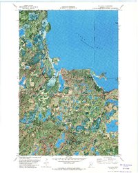
1971 Map of Jack Lake
USGS Topo · Published 1974About this map
The vast waters of Leech Lake dominate the northern portion of this orthophotomap, revealing a complex shoreline within the Chippewa National Forest. This 1971 aerial perspective captures the intricate hydrology of the Leech Lake Indian Reservation, where dozens of smaller water bodies like Hovde Lake, Shell Lake, and Pine Lake are scattered through dense forest and wetlands. The use of orthophotography provides a literal view of the vegetation patterns and water levels of the era, showing the "indefinite boundary" along the eastern lake edge and the specific landforms of Rogers Point and Pelican Island. Aside from a Gravel Pit and a sparse network of unimproved roads, the landscape remains largely defined by its natural features, including Rice Lake in the northwest and the clustered Hanson Lakes further south.
Find a feature on this map
33 named features on this map. Tap any name to fly to it.
Don’t see what you’re looking for? This feature index may not catch every label — zoom into the map to look around manually.
Map Details
Editions of this 1971 Jack Lake Map
2 editions found
Other maps of this area

1953 · Brainerd
USGS Topo · 1:250,000

1954 · Bemidji
USGS Topo · 1:250,000

1957 · Brainerd
USGS Topo · 1:250,000

1957 · Bemidji
USGS Topo · 1:250,000

1958 · Bemidji
USGS Topo · 1:250,000

1958 · Brainerd
USGS Topo · 1:250,000

1965 · Brainerd
USGS Topo · 1:250,000

1970 · Hackensack
USGS Topo · 1:24,000

1970 · Webb Lake
USGS Topo · 1:24,000

1970 · Woman Lake
USGS Topo · 1:24,000