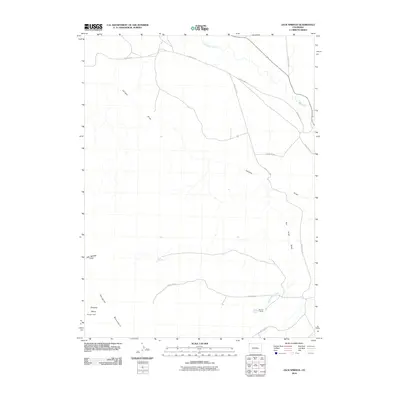
2010 Map of Jack Springs
USGS Topo · Published 2010About this map
Douglas Mountain and the high-altitude landscape of northwest Colorado define this territory, where isolated outposts like Warrick Ranch and Basset Cabin mark the human presence. This 2010 survey illustrates a region shaped by complex drainage systems, including the long paths of Conway Draw and Rye Grass Draw that eventually meet Vermillion Creek. The namesake Jack Springs and Jack Springs Draw sit near the center of the sheet, providing vital water sources in an arid terrain. A network of primitive routes, including County Rd 56 and County Rd 34, navigate the basin floor, linking the remote Zenobia Basin to the wider county. The map serves as a record of rangeland infrastructure and the persistent legacy of early ranching families in this corner of the state.
Find a feature on this map
17 named features on this map. Tap any name to fly to it.
Don’t see what you’re looking for? This feature index may not catch every label — zoom into the map to look around manually.
Map Details
Editions of this 2010 Jack Springs Map
This is the sole edition of this map. No revisions or reprints were ever made.
Other maps of this area

1954 · Lodore School
USGS Topo · 1:24,000

1954 · Canyon of Lodore South
USGS Topo · 1:24,000

1954 · Canyon of Lodore North
USGS Topo · 1:24,000

1954 · Vernal
USGS Topo · 1:250,000

1958 · Vernal
USGS Topo · 1:250,000

1960 · Vernal
USGS Topo · 1:250,000

1966 · Big Joe Basin
USGS Topo · 1:24,000

1966 · Irish Canyon
USGS Topo · 1:24,000
1966 · Greystone
USGS Topo · 1:24,000
1966 · Zenobia Peak
USGS Topo · 1:24,000