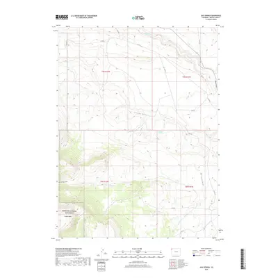
2019 Map of Jack Springs
USGS Topo · Published 2019About this map
Dinosaur National Monument occupies the southern reaches of this high-desert landscape in Moffat County, where the terrain transitions into the deep folds of the Zenobia Basin. The map reveals a land defined by its scarce water sources and dramatic relief, centered on the reliable flow of Jack Springs and the hidden Dripping Rock Spring. A network of drainage systems, including Jack Springs Draw, Rye Grass Draw, and Douglas Draw, carve through the plateau toward the intermittent waters of Vermillion Cr. This territory is sparsely populated, dominated by wide-open ranching land and public preserves, with access provided by remote corridors like Co RD 34 and Co RD 56. The placement of these roads and the naming of specific draws and basins reflect the enduring geographical importance of natural features in navigating this portion of the Colorado backcountry.
Find a feature on this map
22 named features on this map. Tap any name to fly to it.
Don’t see what you’re looking for? This feature index may not catch every label — zoom into the map to look around manually.
Map Details
Editions of this 2019 Jack Springs Map
This is the sole edition of this map. No revisions or reprints were ever made.
Other maps of this area

1954 · Lodore School
USGS Topo · 1:24,000

1954 · Canyon of Lodore South
USGS Topo · 1:24,000

1954 · Canyon of Lodore North
USGS Topo · 1:24,000

1954 · Vernal
USGS Topo · 1:250,000

1958 · Vernal
USGS Topo · 1:250,000

1960 · Vernal
USGS Topo · 1:250,000

1966 · Big Joe Basin
USGS Topo · 1:24,000

1966 · Irish Canyon
USGS Topo · 1:24,000
1966 · Greystone
USGS Topo · 1:24,000
1966 · Zenobia Peak
USGS Topo · 1:24,000