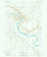
1947 Map of Jackass Butte
USGS Topo · Published 1980About this map
Snake River canyon walls dominate this landscape at the intersection of Owyhee, Elmore, and Ada counties. The winding river corridor is flanked by prominent geological formations like Jackass Butte and Black Butte, while the Emigrant Trail skirts the northern bluffs, marking a historical corridor of westward movement. This post-war survey illustrates a transition from the river's natural course to an engineered agricultural landscape, particularly evident in the Chattin Flats area. Here, an intricate network of irrigation infrastructure including the High Line Canal, Middle Line Canal, and Low Line Canal works in tandem with the Grand View Mutual Irrigation District Canal to bring water to the arid terrain. Scattered signs of local habitation and community appear through landmarks such as Brooks Ranch and the Birch Creek Sch near the mouth of Birch Creek.
Find a feature on this map
20 named features on this map. Tap any name to fly to it.
Don’t see what you’re looking for? This feature index may not catch every label — zoom into the map to look around manually.
Map Details
Editions of this 1947 Jackass Butte Map
2 editions found
Other maps of this area

1892 · Bisuka
USGS Topo · 1:125,000

1894 · Bisuka
USGS Topo · 1:125,000

1947 · Grand View
USGS Topo · 1:62,500

1947 · Grand View
USGS Topo · 1:24,000

1947 · Jackass Butte
USGS Topo · 1:24,000

1947 · Wild Horse Butte
USGS Topo · 1:24,000

1947 · Vinson Wash
USGS Topo · 1:24,000

1947 · Dorsey Butte
USGS Topo · 1:24,000

1948 · Castle Butte
USGS Topo · 1:24,000

1948 · Vinson Wash
USGS Topo · 1:24,000