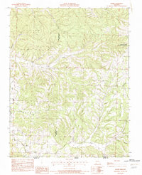
1982 Map of Jacket
USGS Topo · Published 1982About this map
Big Sugar Creek and its many tributaries define the topography of this corner of the Ozarks, where the borders of Missouri, Arkansas, and Oklahoma nearly meet. In the early 1980s, the landscape here remained dominated by complex drainage systems and ridges, with small settlements like Jacket and Trent positioned along winding rural routes. The map illustrates the rugged transition from the Mountain heights down into deep-cut ravines like Pigeon Roost Hollow and Cracker Neck Hollow. Significant public land is noted at the Washburn Tower Site State Public Hunting Grounds, while the southeastern corner shows the fringes of Seligman near the state line. This survey captures a moment before modern development, preserving the placement of isolated homesteads and the network of unimproved roads that connected these remote communities across McDonald and Barry Counties.
Find a feature on this map
27 named features on this map. Tap any name to fly to it.
Don’t see what you’re looking for? This feature index may not catch every label — zoom into the map to look around manually.
Map Details
Editions of this 1982 Jacket Map
This is the sole edition of this map. No revisions or reprints were ever made.
Other maps of this area

1899 · Fayetteville
USGS Topo · 1:125,000

1900 · Eureka Springs
USGS Topo · 1:125,000

1901 · Eureka Springs
USGS Topo · 1:125,000

1901 · Fayetteville
USGS Topo · 1:125,000

1904 · Fayetteville
USGS Topo · 1:125,000

1937 · Cassville
USGS Topo · 1:48,000

1941 · Rocky Comfort
USGS Topo · 1:62,500

1943 · Rocky Comfort
USGS Topo · 1:62,500

1944 · Cassville
USGS Topo · 1:62,500

1945 · Harrison
USGS Topo · 1:250,000