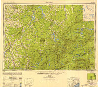
1949 Map of Jackman
USGS Topo · Published 1951About this map
The Canadian Pacific railroad cuts through this borderlands landscape, connecting the industrial centers of Quebec with the timberlands of Northern Maine. Compiled in the late 1940s, this survey documents the complex international boundary where the Eastern Townships meet the High Peaks region. The Salmon River and Chaudiere River drainage systems define the northern terrain, while the southern portion is dominated by the massive profiles of Bigelow Mountain and Sugarloaf Mt. Significant water bodies like Lake Megantic, Flagstaff Lake, and the First Connecticut Lake serve as anchors for the scattered settlements of Megantic, Woburn, and Beecher Falls. This map illustrates the transition from the relatively dense agricultural and railway villages of Quebec, such as St Evariste Station, to the more mountainous, stream-cut forests of Somerset and Franklin counties.
Find a feature on this map
158 named features on this map. Tap any name to fly to it.
Don’t see what you’re looking for? This feature index may not catch every label — zoom into the map to look around manually.
Map Details
Editions of this 1949 Jackman Map
2 editions found

Other maps of this area

1903 · Bingham
USGS Topo · 1:62,500

1904 · Anson
USGS Topo · 1:62,500

1905 · Bingham
USGS Topo · 1:62,500

1905 · The Forks
USGS Topo · 1:62,500

1907 · The Forks
USGS Topo · 1:62,500

1919 · Lake Memphremagog
USGS Topo · 1:62,500

1920 · Derby
USGS Topo · 1:62,500

1921 · Brassua Lake
USGS Topo · 1:62,500

1922 · Long Pond
USGS Topo · 1:62,500

1923 · Brassua Lake
USGS Topo · 1:62,500