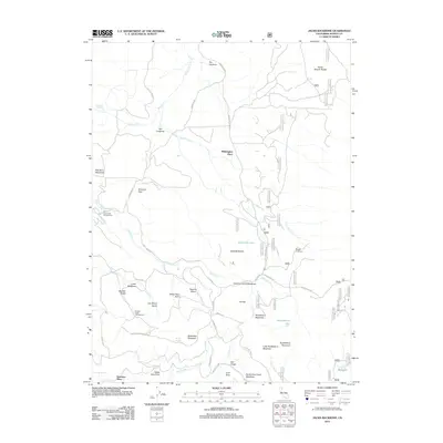
2012 Map of Jacks Backbone
USGS Topo · Published 2012About this map
Whittington Place and Bateman Place mark the sparse human footprint in this high-elevation corner of Shasta County. The landscape is defined by its complex drainage network and rugged geological features, notably the titular Jacks Backbone and the nearby Backbone Lake. Timber and forest management history is evident through the network of logging and service roads like Scott Lumber Rd, which wind through named clearings and flats such as Sheraton Flats and Dan Hunt Meadows.
Find a feature on this map
50 named features on this map. Tap any name to fly to it.
Don’t see what you’re looking for? This feature index may not catch every label — zoom into the map to look around manually.
Map Details
Editions of this 2012 Jacks Backbone Map
This is the sole edition of this map. No revisions or reprints were ever made.
Other maps of this area

1886 · Lassen Peak
USGS Topo · 1:250,000

1892 · Lassen Peak
USGS Topo · 1:250,000

1894 · Lassen Peak
USGS Topo · 1:250,000

1935 · Burney
USGS Topo · 1:96,000

1939 · Burney
USGS Topo · 1:125,000

1955 · Westwood
USGS Topo · 1:250,000

1956 · Manzanita Lake
USGS Topo · 1:62,500
1956 · Whitmore
USGS Topo · 1:62,500
1956 · Montgomery Creek
USGS Topo · 1:62,500

1957 · Burney
USGS Topo · 1:62,500