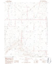
1986 Map of Jacks Knob
USGS Topo · Published 1987About this map
Jacks Knob serves as a central landmark for this arid high-desert landscape situated along the border of Emery Co and Wayne Co. The terrain is defined by dramatic geological formations, most notably the towering Red Reef in the north and Sweetwater Reef to the southwest, which create distinct natural barriers across the quadrangle. Water sources are scarce and localized, represented by specialized features like Moonshine Well and the remote Twin Springs near the entrance to Middle Canyon. This 1980s field revision records the distribution of vital water points, including Dugout Spring and Upper Dugout Spring, which historically supported cattle ranching and seasonal movement through the region's expansive washes. The map captures a moment when traditional land use patterns remained evident through these named springs and the network of primitive routes connecting them.
Find a feature on this map
11 named features on this map. Tap any name to fly to it.
Don’t see what you’re looking for? This feature index may not catch every label — zoom into the map to look around manually.
Map Details
Editions of this 1986 Jacks Knob Map
This is the sole edition of this map. No revisions or reprints were ever made.
Other maps of this area

1885 · San Rafael
USGS Topo · 1:250,000

1953 · Tidwell 3 NW
USGS Topo · 1:24,000

1953 · The Spur
USGS Topo · 1:62,500

1956 · Salina
USGS Topo · 1:250,000

1960 · Salina
USGS Topo · 1:250,000

1962 · Salina
USGS Topo · 1:250,000

1963 · Robbers Roost Canyon
USGS Topo · 1:62,500
1963 · Bowknot Bend
USGS Topo · 1:62,500
1963 · The Flat Tops
USGS Topo · 1:62,500
1980 · Hanksville
USGS Topo · 1:100,000