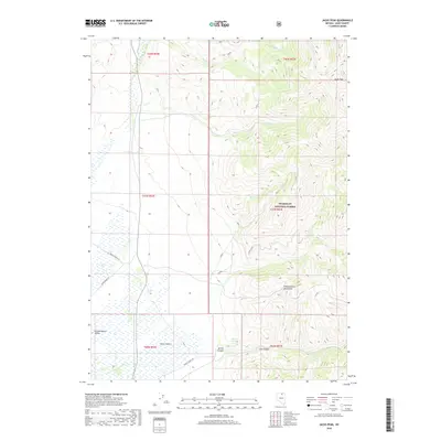
2018 Map of Jacks Peak
USGS Topo · Published 2018About this map
The Independence Mountains dominate this high-altitude landscape of northern Elko County, rising toward the summit of Jacks Peak. This 2018 survey reveals a terrain defined by the transition from the arid expanse of Independence Valley in the southwest to the protected slopes of the Humboldt National Forest in the northeast. The map provides a detailed view of the water sources and drainages essential to the region's ranching and natural character, including Niagara Spring, Bull Cr, and Marsh Cr.
Find a feature on this map
21 named features on this map. Tap any name to fly to it.
Don’t see what you’re looking for? This feature index may not catch every label — zoom into the map to look around manually.
Map Details
Editions of this 2018 Jacks Peak Map
This is the sole edition of this map. No revisions or reprints were ever made.
Other maps of this area

1955 · McDermitt
USGS Topo · 1:250,000

1955 · Wells
USGS Topo · 1:250,000

1956 · Tuscarora
USGS Topo · 1:62,500

1956 · Bull Run
USGS Topo · 1:62,500

1956 · Wild Horse
USGS Topo · 1:62,500

1958 · Wells
USGS Topo · 1:250,000

1959 · McDermitt
USGS Topo · 1:250,000

1961 · Wells
USGS Topo · 1:250,000

1971 · Mahala Creek West
USGS Topo · 1:24,000

1971 · California Mtn.
USGS Topo · 1:24,000