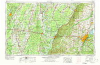
1955 Map of Jackson
USGS Topo · Published 1975About this map
The Mississippi River carves a complex path through the heart of this mid-century landscape, defining the boundary between Louisiana parishes and Mississippi counties. The terrain shifts from the low-lying Delta and Delta National Forest to the rising Loess Hills in the east. Strategic centers like Vicksburg, anchored by the Vicksburg National Military Park, and Jackson show their development as regional hubs connected by U.S. 80 and the emerging I-20 corridor.
Find a feature on this map
69 named features on this map. Tap any name to fly to it.
Don’t see what you’re looking for? This feature index may not catch every label — zoom into the map to look around manually.
Map Details
Editions of this 1955 Jackson Map
3 editions found

Other maps of this area

1903 · Jackson
USGS Topo · 1:125,000

1905 · Jackson
USGS Topo · 1:48,000

1906 · Florence
USGS Topo · 1:62,500

1908 · Jackson
USGS Topo · 1:62,500

1908 · Florence
USGS Topo · 1:62,500

1909 · Delta Bridge
USGS Topo · 1:24,000

1909 · Lake Bruen
USGS Topo · 1:24,000

1909 · Baxter Bayou
USGS Topo · 1:24,000

1909 · Millikens Bend
USGS Topo · 1:24,000

1909 · Lake Providence
USGS Topo · 1:24,000