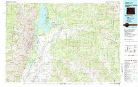
1981 Map of Jackson Lake
USGS Topo · Published 1981About this map
Jackson Lake and the Snake River corridor anchor this 1981 survey of the northwestern Wyoming landscape. The map highlights the sprawling reaches of Grand Teton National Park and the National Elk Refuge, alongside established outposts like Colter Bay Village and Jackson Lake Lodge. The convergence of Us 26, Us 287, and Us 191 at Moran Junction illustrates the region's transport network before the turn of the century. Beyond the major thoroughfares, the map records the locations of smaller communities such as Kelly and Wilson, and the placement of the Jackson Hole Airport. Topographical detail is immense, tracing the Teton Range through named peaks like Mount Moran and Grand Teton, while also capturing drainage systems like Buffalo Fork and Gros Ventre River. To the east, the map extends into the high mountain crossings of Togwotee Pass and Sheridan Pass.
Find a feature on this map
93 named features on this map. Tap any name to fly to it.
Don’t see what you’re looking for? This feature index may not catch every label — zoom into the map to look around manually.
Map Details
Editions of this 1981 Jackson Lake Map
2 editions found
Other maps of this area

1885 · Lake
USGS Topo · 1:125,000

1886 · Shoshone
USGS Topo · 1:125,000

1888 · Shoshone
USGS Topo · 1:125,000

1893 · Ishawooa
USGS Topo · 1:125,000

1895 · Shoshone
USGS Topo · 1:125,000

1895 · Ishawooa
USGS Topo · 1:125,000

1895 · Lake
USGS Topo · 1:125,000

1896 · Lake
USGS Topo · 1:125,000

1899 · Ishawooa
USGS Topo · 1:125,000

1899 · Grand Teton
USGS Topo · 1:125,000