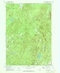
1970 Map of Jackson Summit
USGS Topo · Published 1972About this map
The Adirondack State Park boundary cuts through this landscape on the Hamilton and Fulton county line, where high-elevation wetlands and steep peaks define the local geography. Small settlements and crossroads like Jackson Summit, Upper Benson, and Lindsley Corners are situated along the lower-lying roads, including Washburn Rd and Jackson Summit Rd East. The area is characterized by numerous vlys and ponds, such as Racker Vly, Lynus Vly, and Vandenburgh Pond, which feed into larger water systems like West Stony Creek. Significant infrastructure is present in the form of the Jackson Summit Reservoir and Cameron Reservoir, which were revised in this era to reflect the changing water management of the region. The map also documents local landmarks like Buttermilk Falls and family-named features such as Ferguson Mtn and Dennies Hollow, providing a clear view of the rural settlement patterns before modern development altered these foothill communities.
Find a feature on this map
61 named features on this map. Tap any name to fly to it.
Don’t see what you’re looking for? This feature index may not catch every label — zoom into the map to look around manually.
Map Details
Editions of this 1970 Jackson Summit Map
2 editions found
Other maps of this area

1899 · Broadalbin
USGS Topo · 1:62,500

1902 · Broadalbin
USGS Topo · 1:62,500

1903 · Gloversville
USGS Topo · 1:62,500

1907 · Lake Pleasant
USGS Topo · 1:62,500

1910 · Stony Creek
USGS Topo · 1:62,500

1943 · Gloversville
USGS Topo · 1:62,500

1945 · Caroga Lake
USGS Topo · 1:24,000

1945 · Northville
USGS Topo · 1:24,000
1945 · Jackson Summit
USGS Topo · 1:24,000
1945 · Broadalbin
USGS Topo · 1:24,000