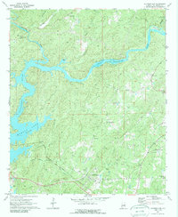
1971 Map of Jacksons Gap
USGS Topo · Published 1989About this map
The Tallapoosa River flows through a landscape defined by the expansive backwaters of Martin Lake and the rural communities of Tallapoosa County in the early 1970s. The town of Jacksons Gap is situated near the Central of Georgia Railroad Grade, serving as a focal point for a region dotted with historic congregations such as New Concord Ch, Eagle Creek Ch, and Woods Ch. To the north, the small settlement of Fosheeton sits near the confluence of Turkey Creek and Hillabee Creek, while the eastern portion of the map includes Tohopeka, reflecting the area's deep ties to Alabama's frontier and indigenous history.
Find a feature on this map
42 named features on this map. Tap any name to fly to it.
Don’t see what you’re looking for? This feature index may not catch every label — zoom into the map to look around manually.
Map Details
Editions of this 1971 Jacksons Gap Map
2 editions found
Other maps of this area

1891 · Ashland
USGS Topo · 1:125,000

1906 · Dadeville
USGS Topo · 1:125,000

1953 · Atlanta
USGS Topo · 1:250,000

1955 · Phenix City
USGS Topo · 1:250,000

1957 · Phenix City
USGS Topo · 1:250,000

1957 · Atlanta
USGS Topo · 1:250,000

1958 · Phenix City
USGS Topo · 1:250,000

1958 · Atlanta
USGS Topo · 1:250,000

1969 · New Site
USGS Topo · 1:24,000
1969 · Hackneyville
USGS Topo · 1:24,000