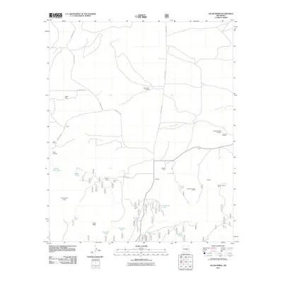
2011 Map of Jacob Spring
USGS Topo · Published 2011About this map
Leslie Ranch and Lacey Ranch anchor this high-altitude landscape in Lincoln County, where the New Mexico ranching tradition persists through a network of named tanks and springs. The terrain is defined by the intersection of Aragon Creek and Carrizo Creek, with local elevations rising toward East Carrizo Cone and the broad Read Mesa. Resource extraction and land management are evident in mining prospects and a density of water catchments including Ten Dollar Tank, Iron Mine Tank, and Dogtown Tank. Further east, the Encinoso Cemetery sits near the mouth of Give-A-Damn Canyon, serving as a genealogical touchstone for the area. The map also documents mid-century mining activity with the McCrory Prospect Sec 36 and its counterpart in Section 31, connected by rural routes such as Iron Pit Rd.
Find a feature on this map
38 named features on this map. Tap any name to fly to it.
Don’t see what you’re looking for? This feature index may not catch every label — zoom into the map to look around manually.
Map Details
Editions of this 2011 Jacob Spring Map
This is the sole edition of this map. No revisions or reprints were ever made.
Other maps of this area

1934 · Capitan
USGS Topo · 1:48,000

1935 · Capitan Mountains
USGS Topo · 1:48,000

1937 · Capitan
USGS Topo · 1:62,500

1940 · Capitan Mountains
USGS Topo · 1:62,500

1955 · Roswell
USGS Topo · 1:250,000

1958 · Roswell
USGS Topo · 1:250,000

1962 · Roswell
USGS Topo · 1:250,000

1973 · Jacob Spring
USGS Topo · 1:24,000
1973 · Nogal
USGS Topo · 1:24,000
1973 · White Oaks North
USGS Topo · 1:24,000