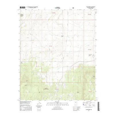
2017 Map of Jacob Spring
USGS Topo · Published 2017About this map
The Lincoln National Forest dominates the southern half of this landscape, where the northern slopes of the Capitan Mountains rise above the high desert floor. This area is defined by a complex network of drainage systems, including the headwaters of Carrizo Cr and Aragon Cr. The naming conventions of the canyons, such as Give-A-Damn Canyon and Gyp Spring Canyon, reflect a local character shaped by ranching and resource management. Water security in this arid environment is evidenced by the numerous named stock tanks, including Ten Dollar Tank, Dogtown Tank, and Section Thirty Tank. Near the eastern boundary, the Encinoso Cem sits at the base of Encinoso Canyon, serving as a permanent record of the small communities that have utilized these mountain foothills. The presence of Read Mesa and E Carrizo Cone provide distinct volcanic and topographical landmarks within the forest boundary.
Find a feature on this map
34 named features on this map. Tap any name to fly to it.
Don’t see what you’re looking for? This feature index may not catch every label — zoom into the map to look around manually.
Map Details
Editions of this 2017 Jacob Spring Map
This is the sole edition of this map. No revisions or reprints were ever made.
Other maps of this area

1934 · Capitan
USGS Topo · 1:48,000

1935 · Capitan Mountains
USGS Topo · 1:48,000

1937 · Capitan
USGS Topo · 1:62,500

1940 · Capitan Mountains
USGS Topo · 1:62,500

1955 · Roswell
USGS Topo · 1:250,000

1958 · Roswell
USGS Topo · 1:250,000

1962 · Roswell
USGS Topo · 1:250,000

1973 · Jacob Spring
USGS Topo · 1:24,000
1973 · Nogal
USGS Topo · 1:24,000
1973 · White Oaks North
USGS Topo · 1:24,000