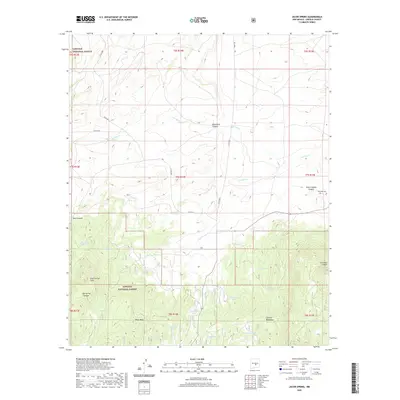
2020 Map of Jacob Spring
USGS Topo · Published 2020About this map
Lincoln National Forest occupies the southern half of this quadrangle, where the northern slopes of the Capitan Mountains rise above the drainage basins of the Carrizo Cr and Aragon Cr. The landscape is defined by its water management infrastructure, featuring a high concentration of stock tanks such as Jacob Tank, Ten Dollar Tank, and Iron Mine Tank. These features, alongside Jacob Spring, indicate a long-standing reliance on concentrated water sources for ranching in this arid environment.
Find a feature on this map
40 named features on this map. Tap any name to fly to it.
Don’t see what you’re looking for? This feature index may not catch every label — zoom into the map to look around manually.
Map Details
Editions of this 2020 Jacob Spring Map
This is the sole edition of this map. No revisions or reprints were ever made.
Other maps of this area

1934 · Capitan
USGS Topo · 1:48,000

1935 · Capitan Mountains
USGS Topo · 1:48,000

1937 · Capitan
USGS Topo · 1:62,500

1940 · Capitan Mountains
USGS Topo · 1:62,500

1955 · Roswell
USGS Topo · 1:250,000

1958 · Roswell
USGS Topo · 1:250,000

1962 · Roswell
USGS Topo · 1:250,000

1973 · Jacob Spring
USGS Topo · 1:24,000
1973 · Nogal
USGS Topo · 1:24,000
1973 · White Oaks North
USGS Topo · 1:24,000