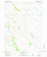
1967 Map of Jacobs Reservoir
USGS Topo · Published 1983About this map
Hart Mountain National Antelope Refuge dominates this high-desert landscape in Lake County, characterized by a complex network of seasonal lakes and alkali flats. The 1967 field data reveals a rugged terrain where water is the primary geographic driver, centered on the Jacobs Reservoir and its drainage through Guano Creek. The map documents a sparsely inhabited region where infrastructure is limited to a network of Jeep Trails, suggesting a landscape dedicated to wildlife conservation and remote ranching operations. Notable landmarks like Cat Butte and the broad Clover Swale provide navigational anchors amidst numerous smaller water bodies, including Fortyfour Lake and School Section Lake. This survey illustrates the delicate balance of the Great Basin ecosystem, recording the specific elevations and locations of vital water sources such as Thunderbird Lake and Wool Lake before modern environmental shifts.
Find a feature on this map
22 named features on this map. Tap any name to fly to it.
Don’t see what you’re looking for? This feature index may not catch every label — zoom into the map to look around manually.
Map Details
Editions of this 1967 Jacobs Reservoir Map
2 editions found
Other maps of this area

1955 · Adel
USGS Topo · 1:250,000

1957 · Adel
USGS Topo · 1:250,000

1958 · Adel
USGS Topo · 1:250,000

1962 · Adel
USGS Topo · 1:250,000

1967 · Jacobs Reservoir
USGS Topo · 1:24,000

1967 · Alger Lake
USGS Topo · 1:24,000

1967 · Hart Lake
USGS Topo · 1:24,000

1967 · Warner Peak
USGS Topo · 1:24,000

1967 · Swede Knoll
USGS Topo · 1:24,000

1967 · Crump Lake
USGS Topo · 1:24,000