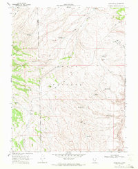
1969 Map of Jakes Knoll
USGS Topo · Published 1972About this map
The Awapa Plateau dominates this high-altitude survey, revealing an intricate system of upland water management used in the late 1960s. The landscape is characterized by numerous small-scale reservoirs positioned to capture runoff in a series of drainage basins, including Pine Point Reservoir, Parker Hollow Reservoir, and Jakes Knoll Reservoir. The presence of these named catchments, such as the Cyclone Co-op Reservoir, points to a shared ranching economy where water rights and access were critical to grazing on the plateau. Scattered features like Chicken Spring and Parker Lake further emphasize the hydrological importance of this terrain. Navigated largely by a network of jeep trails, the area is bisected by the boundary between Piute and Wayne counties, anchored by distinctive landmarks like Red Knoll and Jakes Knoll.
Find a feature on this map
28 named features on this map. Tap any name to fly to it.
Don’t see what you’re looking for? This feature index may not catch every label — zoom into the map to look around manually.
Map Details
Editions of this 1969 Jakes Knoll Map
2 editions found
Other maps of this area

1885 · Fish Lake
USGS Topo · 1:250,000

1896 · Fish Lake
USGS Topo · 1:250,000

1956 · Salina
USGS Topo · 1:250,000

1960 · Salina
USGS Topo · 1:250,000

1962 · Salina
USGS Topo · 1:250,000
1969 · Parker Knoll
USGS Topo · 1:24,000
1969 · Smooth Knoll
USGS Topo · 1:24,000
1969 · Flossie Knoll
USGS Topo · 1:24,000
1969 · Greenwich
USGS Topo · 1:24,000
1969 · Moroni Peak
USGS Topo · 1:24,000