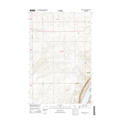
2014 Map of Jameson Lake SE
USGS Topo · Published 2014About this map
The dramatic geological formation of the Grand Coulee dominates the eastern edge of this survey, where the landscape drops sharply into the Lower Grand Coulee. This section of the coulee contains the northern reaches of Lenore Lake, framed by sheer basalt cliffs. On the plateau above, a grid of rural roads including Baseline Rd and Whitehall Rd SE organizes the agricultural landscape of Douglas and Grant Counties. The presence of Highland Cem near the intersection of Baseline and the Us-2 highway provides a specific point of interest for genealogists tracing early families in this arid region. The terrain is further defined by deep cuts into the coulee walls, such as Coyote Canyon and Hybel Canyon, which illustrate the erosion patterns characteristic of the Channeled Scablands.
Find a feature on this map
22 named features on this map. Tap any name to fly to it.
Don’t see what you’re looking for? This feature index may not catch every label — zoom into the map to look around manually.
Map Details
Editions of this 2014 Jameson Lake SE Map
This is the sole edition of this map. No revisions or reprints were ever made.
Other maps of this area

1953 · Ritzville
USGS Topo · 1:250,000

1956 · Ephrata
USGS Topo · 1:62,500

1956 · Soap Lake
USGS Topo · 1:24,000

1959 · Ritzville
USGS Topo · 1:250,000

1965 · Ritzville
USGS Topo · 1:250,000

1965 · Jameson Lake SW
USGS Topo · 1:24,000

1965 · Jameson Lake SE
USGS Topo · 1:24,000

1965 · St. Andrews
USGS Topo · 1:24,000

1965 · Jameson Lake West
USGS Topo · 1:24,000

1965 · Jameson Lake East
USGS Topo · 1:24,000