
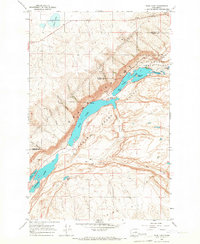
1965 Map of Jameson Lake SE
USGS Topo · Published 1966About this map
The dramatic geological boundary of Grand Coulee dominates the southeastern corner of this mid-1960s survey, where the deep basalt chasm of the Lower Grand Coulee meets the northern tip of Lenore Lake. This landscape, shaped by cataclysmic floods, transitions from the sheer cliffs of the coulee into the upland plateaus of the Douglas and Grant county lines. On the higher ground, a sparse network of rural life is visible, centered on the Highland Sch and the nearby Highland Cemetery.
Find a feature on this map
14 named features on this map. Tap any name to fly to it.
Don’t see what you’re looking for? This feature index may not catch every label — zoom into the map to look around manually.
Map Details
Editions of this 1965 Jameson Lake SE Map
This is the sole edition of this map. No revisions or reprints were ever made.
Other maps of this area

1953 · Ritzville
USGS Topo · 1:250,000

1956 · Ephrata
USGS Topo · 1:62,500

1956 · Soap Lake
USGS Topo · 1:24,000

1959 · Ritzville
USGS Topo · 1:250,000

1965 · Ritzville
USGS Topo · 1:250,000

1965 · Jameson Lake SW
USGS Topo · 1:24,000

1965 · St. Andrews
USGS Topo · 1:24,000

1965 · Jameson Lake West
USGS Topo · 1:24,000

1965 · Jameson Lake East
USGS Topo · 1:24,000
1965 · Park Lake
USGS Topo · 1:24,000