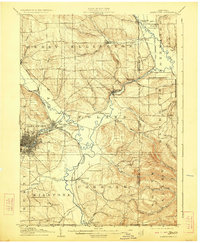
1905 Map of Jamestown
USGS Topo · Published 1923About this map
Jamestown stands as the industrial and population hub of this southwestern New York landscape, situated at the confluence of several vital waterways including Moon Creek and the Cassadaga Creek. The city's growing grid is flanked by the Erie R. R. and the Pittsburgh and Jamestown Line, illustrating its early role as a rail-driven manufacturing center. To the east and south, the map reveals a shift toward agrarian and valley settlements, where Conewango Creek snakes through the lowlands past Frewsburg and Fentonville near the New York Pennsylvania Boundary Line.
Find a feature on this map
57 named features on this map. Tap any name to fly to it.
Don’t see what you’re looking for? This feature index may not catch every label — zoom into the map to look around manually.
Map Details
Editions of this 1905 Jamestown Map
5 editions found
Other maps of this area

1900 · Dunkirk
USGS Topo · 1:62,500

1900 · Cherry Creek
USGS Topo · 1:62,500

1904 · Chautaqua
USGS Topo · 1:62,500

1905 · Jamestown
USGS Topo · 1:62,500

1906 · Warren
USGS Topo · 1:62,500

1907 · Warren
USGS Topo · 1:62,500

1908 · Warren
USGS Topo · 1:62,500

1922 · Randolph
USGS Topo · 1:62,500

1923 · Randolph
USGS Topo · 1:62,500

1923 · Cattaraugus
USGS Topo · 1:62,500