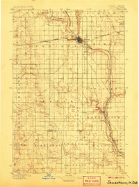
1896 Map of Jamestown
USGS Topo · Published 1906About this map
The Jamestown settlement serves as the primary hub of this late 19th-century landscape, positioned at the critical junction where the Northern Pacific railroad meets the meandering James River. The map illustrates a transitional period of agricultural development, showing a grid of townships like Buchanan, Albion, and Homer overlaying the prairie drainage systems of Pipestem Creek and Sevenmile Coulee. To the west, the rail line stretches through Eldridge, while the river valley to the south supports smaller stations and sidings such as Ypsilanti and Montpelier. The detailed topography recorded by Van H. Manning reveals the complex coulees and creek beds that defined movement across the Dakota territory before widespread road development, including the southern reaches of Beaver Creek and the remote outpost at Sharlow near the Stutsman Co. LaMoure Co. Boundary Line.
Find a feature on this map
30 named features on this map. Tap any name to fly to it.
Don’t see what you’re looking for? This feature index may not catch every label — zoom into the map to look around manually.
Map Details
Editions of this 1896 Jamestown Map
3 editions found
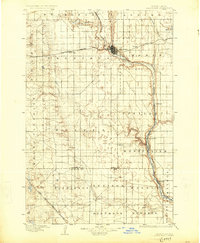
Other maps of this area

1894 · La Moure
USGS Topo · 1:62,500

1895 · Lamoure
USGS Topo · 1:125,000

1896 · Jamestown
USGS Topo · 1:125,000

1896 · Edgeley
USGS Topo · 1:125,000

1897 · Eckelson
USGS Topo · 1:125,000

1900 · Pingree
USGS Topo · 1:125,000

1900 · Pingree
USGS Topo · 1:62,500

1918 · La Moure
USGS Topo · 1:125,000

1925 · Edgeley
USGS Topo · 1:125,000

1950 · Buchanan
USGS Topo · 1:24,000