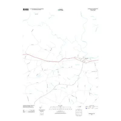
2013 Map of Jamesville
USGS Topo · Published 2013About this map
The Roanoke River dominates the northern reaches of this coastal plain landscape, winding through a complex network of waterways including Devils Gut, Kaders Eddy, and Spellers Creek. The town of Jamesville serves as the primary settlement, situated where the high ground meets the river's edge. South of the main river corridor, the terrain transitions into an expansive system of wetlands and bottomlands, notably Cooper Swamp and Deep Run Swamp. This 2013 survey illustrates how modern transit corridors like W Main St and several state routes connect the riverfront to the interior's agricultural and swamp lands. Local history is etched into the road names, with routes like Holly Springs Church Rd and Fairview Church Rd pointing to community hubs, while Tar Landing reflects the region's historical ties to the naval stores industry and river commerce.
Find a feature on this map
65 named features on this map. Tap any name to fly to it.
Don’t see what you’re looking for? This feature index may not catch every label — zoom into the map to look around manually.
Map Details
Editions of this 2013 Jamesville Map
This is the sole edition of this map. No revisions or reprints were ever made.
Other maps of this area

1901 · Williamston
USGS Topo · 1:62,500

1902 · Williamston
USGS Topo · 1:62,500

1903 · Chocowinity
USGS Topo · 1:62,500

1905 · Chocowinity
USGS Topo · 1:62,500

1943 · Plymouth
USGS Topo · 1:125,000

1953 · Rocky Mount
USGS Topo · 1:250,000

1954 · Rocky Mount
USGS Topo · 1:250,000
1978 · Farmlife
USGS Topo · 1:24,000
1978 · Hoke
USGS Topo · 1:24,000
1978 · Jamesville
USGS Topo · 1:24,000