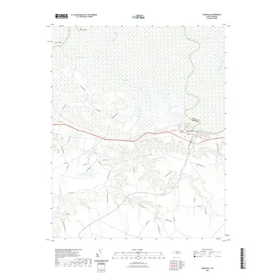
2021 Map of Jamesville
USGS Topo · Published 2021About this map
The Roanoke River dominates the northern reaches of this coastal plain landscape, winding its way through a dense network of wetlands and tributary channels along the Bertie Co and Martin Co line. The settlement of Jamesville serves as the primary hub, situated on the southern bank where the river curves. This area is defined by its complex hydrography, featuring intricate waterways such as Devils Gut, Spellers Creek, and Gardner Creek that thread through the low-lying terrain near Conine Island. South of the river, the landscape transitions into a series of named wetlands, including Cooper Swamp, Deep Run Swamp, and Lanier Swamp. A network of rural roads, many bearing family names like Wendell-Griffin Rd and Arthur Modlin Rd, connects the scattered homesteads and agricultural lands that occupy the higher ground between these swampy basins.
Find a feature on this map
54 named features on this map. Tap any name to fly to it.
Don’t see what you’re looking for? This feature index may not catch every label — zoom into the map to look around manually.
Map Details
Editions of this 2021 Jamesville Map
This is the sole edition of this map. No revisions or reprints were ever made.
Other maps of this area

1901 · Williamston
USGS Topo · 1:62,500

1902 · Williamston
USGS Topo · 1:62,500

1903 · Chocowinity
USGS Topo · 1:62,500

1905 · Chocowinity
USGS Topo · 1:62,500

1943 · Plymouth
USGS Topo · 1:125,000

1953 · Rocky Mount
USGS Topo · 1:250,000

1954 · Rocky Mount
USGS Topo · 1:250,000
1978 · Farmlife
USGS Topo · 1:24,000
1978 · Hoke
USGS Topo · 1:24,000
1978 · Jamesville
USGS Topo · 1:24,000