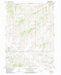
1983 Map of Jamison
USGS Topo · Published 1984About this map
Jamison serves as the primary settlement in this section of Iowa, situated along an Old Railroad Grade that speaks to the changing transportation routes of the late twentieth century. The landscape is heavily defined by the intricate drainage systems of the Otter Creek watershed, featuring North Otter Creek, Middle Otter Creek, and South Otter Creek as they wind through the townships of Fremont, Liberty, and Osceola. Genealogy researchers will find the Union Chapel Cem as a key landmark of local heritage.
Find a feature on this map
19 named features on this map. Tap any name to fly to it.
Don’t see what you’re looking for? This feature index may not catch every label — zoom into the map to look around manually.
Map Details
Editions of this 1983 Jamison Map
This is the sole edition of this map. No revisions or reprints were ever made.
Other maps of this area

1950 · New Virginia
USGS Topo · 1:62,500

1951 · Osceola
USGS Topo · 1:62,500

1952 · New Virginia
USGS Topo · 1:62,500

1954 · Centerville
USGS Topo · 1:250,000

1954 · Des Moines
USGS Topo · 1:250,000

1956 · Des Moines
USGS Topo · 1:250,000

1957 · Des Moines
USGS Topo · 1:250,000

1957 · Centerville
USGS Topo · 1:250,000

1958 · Centerville
USGS Topo · 1:250,000

1965 · Weldon
USGS Topo · 1:24,000