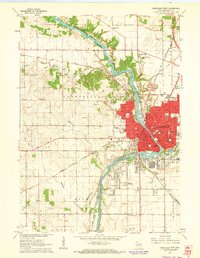
1961 Map of Janesville West
USGS Topo · Published 1964About this map
The Rock River winds through the heart of Janesville, acting as the central axis for this early 1960s industrial and residential hub. The map reveals a dense network of civic and social infrastructure, from the Pinehurst Sanatorium and County Institution in the north to the Rock County Airport at the southern boundary. Two major rail lines, the Chicago and North Western and the Chicago Milwaukee St Paul and Pacific, converge near the city center, illustrating the importance of rail transport for the local economy.
Find a feature on this map
75 named features on this map. Tap any name to fly to it.
Don’t see what you’re looking for? This feature index may not catch every label — zoom into the map to look around manually.
Map Details
Editions of this 1961 Janesville West Map
3 editions found
Other maps of this area

1890 · Stoughton
USGS Topo · 1:62,500

1891 · Koshkonong
USGS Topo · 1:62,500

1891 · Janesville
USGS Topo · 1:62,500

1893 · Janesville
USGS Topo · 1:62,500

1893 · Shopiere
USGS Topo · 1:62,500

1894 · Koshkonong
USGS Topo · 1:62,500

1906 · Koshkonong
USGS Topo · 1:62,500

1954 · Rockford
USGS Topo · 1:250,000

1955 · Rockford
USGS Topo · 1:250,000

1958 · Rockford
USGS Topo · 1:250,000