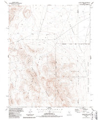
1986 Map of Jangle Ridge
USGS Topo · Published 1987About this map
The Nevada Test Site dominates this 1980s landscape, illustrating the intersection of military operations and public land management in the high desert. This restricted area, bordering the Nellis Air Force Range, is defined by topographic features like the Half Pint Range and Jangle Ridge. The map shows a transition from the mountainous heights of Banded Mountain and the Rhyolite Hills down to the broad expanse of Emigrant Valley.
Find a feature on this map
20 named features on this map. Tap any name to fly to it.
Don’t see what you’re looking for? This feature index may not catch every label — zoom into the map to look around manually.
Map Details
Editions of this 1986 Jangle Ridge Map
This is the sole edition of this map. No revisions or reprints were ever made.
Other maps of this area

1908 · Kawich
USGS Topo · 1:250,000

1942 · Emigrant Valley
USGS Topo · 1:125,000

1942 · Wheelbarrow Peak
USGS Topo · 1:125,000

1952 · Tippipah Spring
USGS Topo · 1:62,500

1952 · Papoose Lake
USGS Topo · 1:62,500

1952 · Wheelbarrow Peak
USGS Topo · 1:62,500

1952 · Groom Mine
USGS Topo · 1:62,500

1954 · Caliente
USGS Topo · 1:250,000

1954 · Goldfield
USGS Topo · 1:250,000

1955 · Goldfield
USGS Topo · 1:250,000