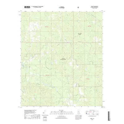
2018 Map of Janice
USGS Topo · Published 2018About this map
De Soto National Forest dominates this section of Perry County, Mississippi, where the settlement of Janice sits at the intersection of Janice School Rd and Bryant Rd. The landscape is defined by the winding course of Black Creek, which is accompanied by the Black Creek Trail as it snakes through the dense woodland. This area reflects a deep integration of military and natural resource management, evidenced by the presence of MTA Camp Shelby in the northern reaches and various fire-watch infrastructure like Paret Tower Rd. Local history is anchored by the Nixon Cem and several family-named roads such as Hershel Ramsey Rd and Lula Cooley Rd, tracing the residential patterns of rural families. The hydrology of the region is intricate, with numerous tributaries like Pearces Cr and Ashley Cr feeding into larger systems, alongside unique features like Howard Reed Brake and Andrew Pond.
Find a feature on this map
47 named features on this map. Tap any name to fly to it.
Don’t see what you’re looking for? This feature index may not catch every label — zoom into the map to look around manually.
Map Details
Editions of this 2018 Janice Map
This is the sole edition of this map. No revisions or reprints were ever made.
Other maps of this area

1947 · Beaumont
USGS Topo · 1:62,500

1947 · Wiggins
USGS Topo · 1:62,500

1947 · New Augusta
USGS Topo · 1:62,500

1947 · Benndale
USGS Topo · 1:62,500

1949 · Wiggins
USGS Topo · 1:62,500

1949 · Beaumont
USGS Topo · 1:62,500

1949 · New Augusta
USGS Topo · 1:62,500

1949 · Benndale
USGS Topo · 1:62,500

1953 · Hattiesburg
USGS Topo · 1:250,000

1953 · Mobile
USGS Topo · 1:250,000