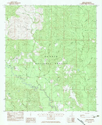
1983 Map of Janice
USGS Topo · Published 1983About this map
De Soto National Forest dominates this section of Perry County, where the winding course of Black Creek carves through the timberland. The map provides a detailed look at the rural landscape in the early 1980s, centered on the small settlement of Janice. Local community life is anchored by landmarks such as St John Ch and Oak Grove Ch, while the Mixon Cem offers a primary point of interest for genealogists tracing family roots in the area. The drainage pattern is exceptionally intricate, with numerous named waterways like Shut Eye Creek, Blue Goose Bay, and the swampy Howard Reed Brake defining the topography. Transportation is primarily limited to the Brooklyn Mc Lain Road and forest routes, including those leading to Moodys Landing on the creek bank.
Find a feature on this map
32 named features on this map. Tap any name to fly to it.
Don’t see what you’re looking for? This feature index may not catch every label — zoom into the map to look around manually.
Map Details
Editions of this 1983 Janice Map
This is the sole edition of this map. No revisions or reprints were ever made.
Other maps of this area

1947 · Beaumont
USGS Topo · 1:62,500

1947 · Wiggins
USGS Topo · 1:62,500

1947 · New Augusta
USGS Topo · 1:62,500

1947 · Benndale
USGS Topo · 1:62,500

1949 · Wiggins
USGS Topo · 1:62,500

1949 · Beaumont
USGS Topo · 1:62,500

1949 · New Augusta
USGS Topo · 1:62,500

1949 · Benndale
USGS Topo · 1:62,500

1953 · Hattiesburg
USGS Topo · 1:250,000

1953 · Mobile
USGS Topo · 1:250,000