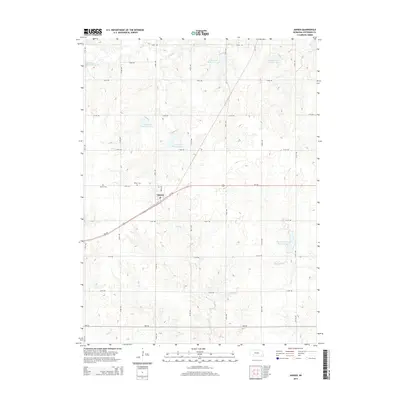
2014 Map of Jansen
USGS Topo · Published 2014About this map
Jansen serves as the central hub of this Jefferson County survey, situated at the intersection of Us-136 and Broad St. The landscape is defined by a dense network of water management features, including several numbered reservoirs such as Cub Creek Reservoir 14-A and Cub Creek Reservoir 13-D. These reservoirs are part of a drainage system feeding into larger waterways like Cub Cr and Rock Cr. For those researching local history, the map provides precise locations for Bartel Cem and Jansen Cem, positioned west of the primary settlement. The terrain transitions from the developed corridor of the highway to the branching creek systems of Elm Cr and Smith Cr in the south, illustrating the agricultural and hydrological layout of the region in the early 21st century.
Find a feature on this map
33 named features on this map. Tap any name to fly to it.
Don’t see what you’re looking for? This feature index may not catch every label — zoom into the map to look around manually.
Map Details
Editions of this 2014 Jansen Map
This is the sole edition of this map. No revisions or reprints were ever made.
Other maps of this area

1955 · Lincoln
USGS Topo · 1:250,000

1957 · Lincoln
USGS Topo · 1:250,000

1957 · Plymouth
USGS Topo · 1:24,000

1958 · Lincoln
USGS Topo · 1:250,000

1960 · Fairbury SW
USGS Topo · 1:24,000

1960 · Western SW
USGS Topo · 1:24,000

1960 · Fairbury
USGS Topo · 1:24,000

1961 · Western SE
USGS Topo · 1:24,000
1970 · Harbine
USGS Topo · 1:24,000
1970 · Endicott
USGS Topo · 1:24,000