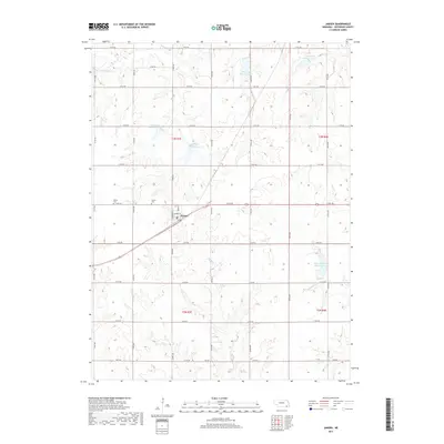
2017 Map of Jansen
USGS Topo · Published 2017About this map
Jansen serves as the central hub of this Jefferson County landscape, situated where the grid of rural roads meets the diagonal passage of the railroad. The town is flanked by the Jansen Cem and Bartel Cem, providing clear points of interest for genealogists tracking local families. The surrounding terrain is defined by a sophisticated water management system, featuring numerous engineered basins such as Cub Creek Reservoir 14-A, Cub Creek Reservoir 13-D, and Big Indian Creek Reservoir 10-A. These reservoirs, distributed across the drainage basins of Cub Cr and Big Indian Cr, illustrate the modern agricultural character of the region. The landscape is further dissected by smaller tributaries like Elm Cr and Smith Cr, which wind through the section lines of the township and range survey system.
Find a feature on this map
30 named features on this map. Tap any name to fly to it.
Don’t see what you’re looking for? This feature index may not catch every label — zoom into the map to look around manually.
Map Details
Editions of this 2017 Jansen Map
This is the sole edition of this map. No revisions or reprints were ever made.
Other maps of this area

1955 · Lincoln
USGS Topo · 1:250,000

1957 · Lincoln
USGS Topo · 1:250,000

1957 · Plymouth
USGS Topo · 1:24,000

1958 · Lincoln
USGS Topo · 1:250,000

1960 · Fairbury SW
USGS Topo · 1:24,000

1960 · Western SW
USGS Topo · 1:24,000

1960 · Fairbury
USGS Topo · 1:24,000

1961 · Western SE
USGS Topo · 1:24,000
1970 · Harbine
USGS Topo · 1:24,000
1970 · Endicott
USGS Topo · 1:24,000