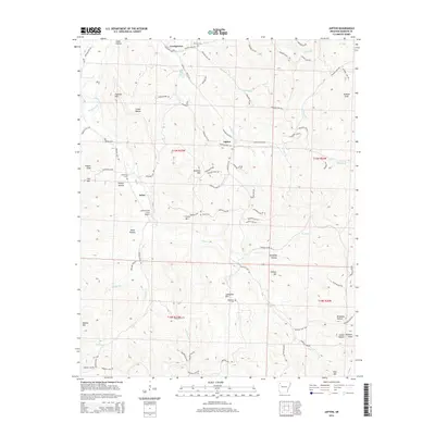
2014 Map of Japton
USGS Topo · Published 2014About this map
Japton and Georgetown anchor this highland landscape in Madison County, where small settlements and family burial grounds are connected by a network of winding county roads like AR 295 Hwy. The terrain is defined by a series of prominent peaks and deep hollows, including Faulkner Mtn, Eubanks Mtn, and Ridley Hollow. Several generational landmarks are preserved here, such as Duncan Cem, Grose Cem, and Ledbetter Cem, providing valuable points of reference for genealogists. Waterways like Drakes Cr and Lollars Cr carve through the topography, influencing the placement of local homesteads and the Lollars Creek Farm Airport. This 2014 survey documents the rural character of the region, illustrating how the community at Asher and surrounding farmsteads adapted to the steep elevations of the Ozark vicinity.
Find a feature on this map
89 named features on this map. Tap any name to fly to it.
Don’t see what you’re looking for? This feature index may not catch every label — zoom into the map to look around manually.
Map Details
Editions of this 2014 Japton Map
This is the sole edition of this map. No revisions or reprints were ever made.
Other maps of this area

1900 · Eureka Springs
USGS Topo · 1:125,000

1901 · Eureka Springs
USGS Topo · 1:125,000

1943 · St. Paul
USGS Topo · 1:62,500

1945 · Harrison
USGS Topo · 1:250,000

1946 · St. Paul
USGS Topo · 1:62,500

1949 · Harrison
USGS Topo · 1:250,000

1954 · Harrison
USGS Topo · 1:250,000

1956 · Russellville
USGS Topo · 1:250,000
1958 · Goshen
USGS Topo · 1:24,000

1958 · Harrison
USGS Topo · 1:250,000