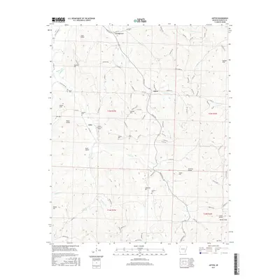
2017 Map of Japton
USGS Topo · Published 2017About this map
The rugged Ozark interior of Madison County is defined by the winding course of Drakes Cr and its many tributaries, such as Lollars Cr and Panther Cr. Small community centers like Japton, Asher, and Georgetown are connected by a network of county roads that follow the ridges and valley floors between prominent peaks like Eubanks Mtn and Faulkner Mtn. For the family historian, the landscape is dotted with ancestral sites, including Duncan Cem, Grose Cem, and Ledbetter Cem. The presence of the Lollars Creek Farm Airport near Asher highlights the intersection of traditional hill country life with modern rural infrastructure. Steep hollows, such as Ridley Hollow and Dunaway Hollow, underscore the localized nature of settlement in this part of Arkansas, where narrow gaps and knobs dictated the placement of homesteads and early transport routes.
Find a feature on this map
97 named features on this map. Tap any name to fly to it.
Don’t see what you’re looking for? This feature index may not catch every label — zoom into the map to look around manually.
Map Details
Editions of this 2017 Japton Map
This is the sole edition of this map. No revisions or reprints were ever made.
Other maps of this area

1900 · Eureka Springs
USGS Topo · 1:125,000

1901 · Eureka Springs
USGS Topo · 1:125,000

1943 · St. Paul
USGS Topo · 1:62,500

1945 · Harrison
USGS Topo · 1:250,000

1946 · St. Paul
USGS Topo · 1:62,500

1949 · Harrison
USGS Topo · 1:250,000

1954 · Harrison
USGS Topo · 1:250,000

1956 · Russellville
USGS Topo · 1:250,000
1958 · Goshen
USGS Topo · 1:24,000

1958 · Harrison
USGS Topo · 1:250,000