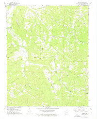
1973 Map of Japton
USGS Topo · Published 1976About this map
Drakes Creek winds through the high ridges of Madison County, framing a landscape defined by isolated homesteads and high summits in the early 1970s. The settlement of Japton serves as a local hub, while smaller communities like Georgetown and Asher anchor the narrow valleys. This survey, completed just before the mid-1970s, reveals a network of mountain roads connecting various family-named landmarks such as Faulkner Mountain and Eubanks Mountain. Local genealogy is well-documented through numerous family burial sites, including the Foster Cem, Duncan Cem, and Grose Cem. The presence of the Mountain Grove Ch and multiple Church of Christ locations suggests the central role of community parishes in these Ozark hollows. Drainage patterns across Ridley Hollow and Rowe Hollow demonstrate how the local topography dictated the placement of early mountain farms and schoolhouses.
Find a feature on this map
38 named features on this map. Tap any name to fly to it.
Don’t see what you’re looking for? This feature index may not catch every label — zoom into the map to look around manually.
Map Details
Editions of this 1973 Japton Map
This is the sole edition of this map. No revisions or reprints were ever made.
Other maps of this area

1900 · Eureka Springs
USGS Topo · 1:125,000

1901 · Eureka Springs
USGS Topo · 1:125,000

1943 · St. Paul
USGS Topo · 1:62,500

1945 · Harrison
USGS Topo · 1:250,000

1946 · St. Paul
USGS Topo · 1:62,500

1949 · Harrison
USGS Topo · 1:250,000

1954 · Harrison
USGS Topo · 1:250,000

1956 · Russellville
USGS Topo · 1:250,000
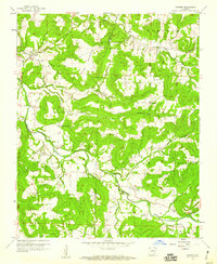
1958 · Goshen
USGS Topo · 1:24,000

1958 · Harrison
USGS Topo · 1:250,000