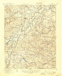
1919 Map of Jarratt
USGS Topo · Published 1944About this map
The Nottoway River meanders through this landscape, which sat at a critical junction of three major rail lines at the end of the 1910s. The Virginian, Atlantic Coast Line, and Southern Railway converged near Jarratt, facilitating the regional timber and agricultural economy seen in landmarks like Podoanas Stave Mill and Harrells Mill. This era in Sussex and Greensville counties is marked by a high density of rural social centers, from the Russian Church and Rising Star Church to local education at the Yale School and Red School.
Find a feature on this map
74 named features on this map. Tap any name to fly to it.
Don’t see what you’re looking for? This feature index may not catch every label — zoom into the map to look around manually.
Map Details
Editions of this 1919 Jarratt Map
3 editions found

Other maps of this area

1894 · Petersburg
USGS Topo · 1:62,500

1897 · Amelia
USGS Topo · 1:125,000

1919 · Jarratt
USGS Topo · 1:62,500

1919 · Mc Kenney
USGS Topo · 1:48,000

1919 · Disputanta
USGS Topo · 1:62,500

1919 · Homeville
USGS Topo · 1:48,000
1919 · Boykins
USGS Topo · 1:48,000

1919 · Emporia
USGS Topo · 1:62,500

1919 · Arringdale
USGS Topo · 1:48,000

1920 · Homeville
USGS Topo · 1:62,500