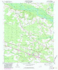
1978 Map of Jasper
USGS Topo · Published 1983About this map
The Neuse River defines the northern reaches of this landscape, its banks dotted with historic river access points like Redhill Landing, Shell Landing, and Cowpen Landing. Moving south from the river, the terrain transitions through a network of small drainages including Turkey Quarter Creek and Stony Branch toward the northern fringes of the Great Dover Swamp. This era of the late 1970s shows the area's development through rural settlements like Jasper and Tuscarora, where local life centered around community anchors like St Johns Ch and Bethany Ch. The Atlantic and East Carolina Railroad serves as a primary transit corridor, cutting through the southern half of the map near the Old Railroad Grade. Industrial and infrastructure elements of the period are evident, from the presence of a Lookout Tower near the tracks to the Sewage Disposal plant and West Craven Jr High Sch further north.
Find a feature on this map
43 named features on this map. Tap any name to fly to it.
Don’t see what you’re looking for? This feature index may not catch every label — zoom into the map to look around manually.
Map Details
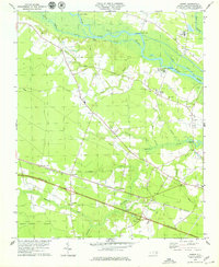
Editions of this 1978 Jasper Map
2 editions found
Other maps of this area

1901 · New Bern
USGS Topo · 1:62,500

1902 · Ayden
USGS Topo · 1:62,500

1902 · Vanceboro
USGS Topo · 1:62,500

1903 · New Bern
USGS Topo · 1:62,500

1903 · Trent River
USGS Topo · 1:62,500

1904 · Ayden
USGS Topo · 1:62,500

1904 · Trent River
USGS Topo · 1:62,500

1904 · Vanceboro
USGS Topo · 1:62,500

1905 · Vanceboro
USGS Topo · 1:62,500

1950 · Pollocksville
USGS Topo · 1:24,000