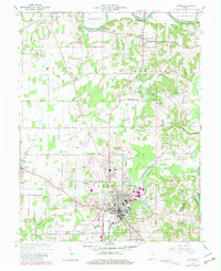
1960 Map of Jasper
USGS Topo · Published 1981About this map
Jasper serves as the industrial and civic anchor of this Dubois County landscape, where the Patoka River winds southward through Bainbridge township. This mid-century view, updated with late-1970s aerial revisions, captures the city during a period of expansion, evidenced by the development of the Country Club and the Trailer Park near the Ackerman Branch. To the north and west, the terrain transitions into a mosaic of small farming communities and timbered drainage basins. The northern border is defined by the East Fork White River near Portersville, a historic river crossing. Throughout the rural townships of Boone, Harbison, and Madison, the map documents several family burial grounds and country congregations, including Shiloh Ch and Alexander Cem, providing essential details for genealogists and local historians tracing the settlement patterns of southwestern Indiana.
Find a feature on this map
88 named features on this map. Tap any name to fly to it.
Don’t see what you’re looking for? This feature index may not catch every label — zoom into the map to look around manually.
Map Details
Editions of this 1960 Jasper Map
4 editions found
Other maps of this area

1902 · Ditney
USGS Topo · 1:125,000

1903 · Velpen
USGS Topo · 1:62,500

1944 · Glendale
USGS Topo · 1:24,000

1946 · Jasper
USGS Topo · 1:24,000

1954 · Dubois
USGS Topo · 1:24,000

1954 · Huntingburg
USGS Topo · 1:24,000

1955 · Saint Anthony
USGS Topo · 1:24,000

1956 · Alfordsville
USGS Topo · 1:24,000

1956 · Rusk
USGS Topo · 1:24,000

1956 · Vincennes
USGS Topo · 1:250,000