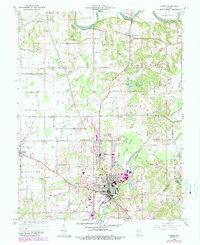
1960 Map of Jasper
USGS Topo · Published 1990About this map
The Patoka River meanders through the heart of Jasper, marking a landscape where mid-century urban expansion meets the rural character of Bainbridge and Madison townships. This 1960 revision, with 1980s updates, documents the growth of the Dubois County seat, showing the proximity of the Country Club and Golf Course to the emerging residential streets. Significant landmarks like St Joseph Sch and the central industrial core contrast with the numerous family cemeteries dotting the periphery, including Sherritt Cem, Shiloh Cem, and Evans Cem.
Find a feature on this map
75 named features on this map. Tap any name to fly to it.
Don’t see what you’re looking for? This feature index may not catch every label — zoom into the map to look around manually.
Map Details
Editions of this 1960 Jasper Map
4 editions found
Other maps of this area

1902 · Ditney
USGS Topo · 1:125,000

1903 · Velpen
USGS Topo · 1:62,500

1944 · Glendale
USGS Topo · 1:24,000

1946 · Jasper
USGS Topo · 1:24,000

1954 · Dubois
USGS Topo · 1:24,000

1954 · Huntingburg
USGS Topo · 1:24,000

1955 · Saint Anthony
USGS Topo · 1:24,000

1956 · Alfordsville
USGS Topo · 1:24,000

1956 · Rusk
USGS Topo · 1:24,000

1956 · Vincennes
USGS Topo · 1:250,000