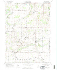
1962 Map of Jasper
USGS Topo · Published 1963About this map
Agricultural development and an extensive network of drainage ditches characterize this southern Michigan landscape just north of the Ohio border. Two major rail corridors, the Wabash Railroad and the New York Central Railroad, intersect the region, facilitating the movement of goods between rural hubs like Weston and Jasper. The topography is subtly defined by the South Branch Raisin River and a complex system of managed waterways, including the Savage Drain, Mitchell Drain, and Black Creek, which underpin the area's productive farmland.
Find a feature on this map
67 named features on this map. Tap any name to fly to it.
Don’t see what you’re looking for? This feature index may not catch every label — zoom into the map to look around manually.
Map Details
Editions of this 1962 Jasper Map
2 editions found
Other maps of this area

1911 · Wauseon
USGS Topo · 1:62,500

1911 · Swanton
USGS Topo · 1:62,500

1913 · Wauseon
USGS Topo · 1:62,500

1914 · Swanton
USGS Topo · 1:62,500

1939 · Blissfield
USGS Topo · 1:62,500

1941 · Blissfield
USGS Topo · 1:62,500

1943 · Wauseon
USGS Topo · 1:62,500

1953 · Fort Wayne
USGS Topo · 1:250,000

1956 · Fort Wayne
USGS Topo · 1:250,000

1956 · Toledo
USGS Topo · 1:250,000