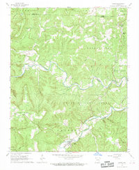
1967 Map of Jasper
USGS Topo · Published 1968About this map
Jasper serves as the focal point of this Newton County landscape, situated at the confluence of the Little Buffalo River and Carlton Branch. The map documents a period of transition for the Ozarks, capturing the emerging Buffalo National River boundary alongside established rural settlements. Further north, the curiosity of Dogpatch (Marble Falls) and Marble Falls sits near the Boone and Newton County line, marking a intersection of local tourism and traditional agriculture.
Find a feature on this map
61 named features on this map. Tap any name to fly to it.
Don’t see what you’re looking for? This feature index may not catch every label — zoom into the map to look around manually.
Map Details
Editions of this 1967 Jasper Map
2 editions found
Other maps of this area

1904 · Harrison
USGS Topo · 1:125,000

1905 · Harrison
USGS Topo · 1:125,000

1933 · Mt Judea
USGS Topo · 1:62,500

1940 · Mt Judea
USGS Topo · 1:62,500

1945 · Harrison
USGS Topo · 1:250,000

1949 · Harrison
USGS Topo · 1:250,000

1954 · Harrison
USGS Topo · 1:250,000

1956 · Russellville
USGS Topo · 1:250,000

1958 · Harrison
USGS Topo · 1:250,000

1964 · Russellville
USGS Topo · 1:250,000