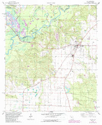
1978 Map of Jay
USGS Topo · Published 1987About this map
The Escambia River and Conecuh River converge along the Florida-Alabama border, defining a landscape of complex waterways and industrial activity. This survey captures the region during a period of significant petroleum production, evidenced by the extensive Oil Field and numerous Oil Wells scattered across the terrain. The town of Jay serves as the primary hub, supported by smaller settlements like Brownsdale, Cobbtown, and Happy Valley.
Find a feature on this map
56 named features on this map. Tap any name to fly to it.
Don’t see what you’re looking for? This feature index may not catch every label — zoom into the map to look around manually.
Map Details
Editions of this 1978 Jay Map
4 editions found
Other maps of this area

1941 · Century
USGS Topo · 1:62,500

1943 · Century
USGS Topo · 1:62,500

1943 · Jay
USGS Topo · 1:62,500

1953 · Andalusia
USGS Topo · 1:250,000

1957 · Andalusia
USGS Topo · 1:250,000

1957 · Pensacola
USGS Topo · 1:250,000

1959 · Pensacola
USGS Topo · 1:250,000

1959 · Brewton South
USGS Topo · 1:24,000

1960 · Pensacola
USGS Topo · 1:250,000

1960 · Brewton South
USGS Topo · 1:24,000