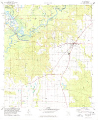
1978 Map of Jay
USGS Topo · Published 1978About this map
The Escambia River and Conecuh River converge along the Alabama-Florida border, shaping a landscape defined by oxbows and swampy depressions like Government Dead Lake and Jernigan Dead River. In the late 1970s, this region was a significant energy hub, dominated by an extensive Oil Field and a network of Pipelines stretching across the agricultural uplands. The town of Jay serves as the local center, featuring a concentrated grid of streets, the High Sch, and the nearby Jay Airport. Away from the town center, the map reveals a rural social geography anchored by country churches and family landmarks, including Ebenezer Ch, Pine Level Ch, and the McCostill Cem. This survey captures the height of local oil production while documenting the persistent settlement patterns of small communities like Brownsdale and Cobbtown.
Find a feature on this map
57 named features on this map. Tap any name to fly to it.
Don’t see what you’re looking for? This feature index may not catch every label — zoom into the map to look around manually.
Map Details
Editions of this 1978 Jay Map
4 editions found
Other maps of this area

1941 · Century
USGS Topo · 1:62,500

1943 · Century
USGS Topo · 1:62,500

1943 · Jay
USGS Topo · 1:62,500

1953 · Andalusia
USGS Topo · 1:250,000

1957 · Andalusia
USGS Topo · 1:250,000

1957 · Pensacola
USGS Topo · 1:250,000

1959 · Pensacola
USGS Topo · 1:250,000

1959 · Brewton South
USGS Topo · 1:24,000

1960 · Pensacola
USGS Topo · 1:250,000

1960 · Brewton South
USGS Topo · 1:24,000