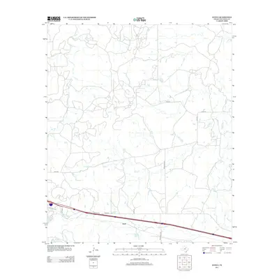
2012 Map of Jayell
USGS Topo · Published 2012About this map
The settlement of Jayell and the surrounding ranchlands of Callahan County define this 2012 topographic record. The landscape is characterized by its reliance on water management for agriculture and transport, as evidenced by several reservoirs including Baird Railroad Lake, T P Lake, and Smith Lake. These features, alongside the drainage networks of Hubbard Cr and Deep Cr, highlight the hydrology of the Texas rolling plains south of the Interstate 20 corridor. The presence of Baird Railroad Lake specifically points to the historical legacy of the Texas and Pacific Railway which once shaped the growth of nearby towns. A network of county roads, such as Co RD-324 and Ranch Road 2228, connects the sparse homesteads and grazing lands that dominate the terrain around Mexia Cr and Brushy Cr.
Find a feature on this map
20 named features on this map. Tap any name to fly to it.
Don’t see what you’re looking for? This feature index may not catch every label — zoom into the map to look around manually.
Map Details
Editions of this 2012 Jayell Map
This is the sole edition of this map. No revisions or reprints were ever made.
Other maps of this area

1892 · Albany
USGS Topo · 1:125,000

1893 · Albany
USGS Topo · 1:125,000

1931 · Baird
USGS Topo · 1:125,000

1932 · Baird
USGS Topo · 1:125,000

1954 · Abilene
USGS Topo · 1:250,000

1958 · Abilene
USGS Topo · 1:250,000
1965 · Snyder Lake
USGS Topo · 1:24,000
1965 · Moran
USGS Topo · 1:24,000
1965 · Leeper Creek
USGS Topo · 1:24,000

1966 · Putnam South
USGS Topo · 1:24,000