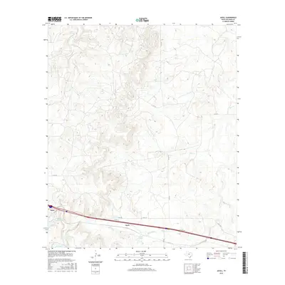
2016 Map of Jayell
USGS Topo · Published 2016About this map
The city of Baird, established as a vital stop for the Texas and Pacific Railway, serves as the primary settlement on this landscape. Its historical reliance on the railroad is evidenced by Baird Railroad Lake and T P Lake, water features whose names reflect the industrial infrastructure required for steam-era transit. To the east, the smaller settlement of Jayell sits along the corridor of Interstate 20, which follows the old westward path of the tracks. The terrain is defined by a network of seasonal watercourses, including Mexia Creek, Hubbard Cr, and Sheep Cr, which drain the undulating lands of Callahan County. Numerous county roads such as Co RD 327 and Co RD 324 weave through the rural parcels, providing access to isolated livestock tanks and small private impoundments like Smith Lake.
Find a feature on this map
21 named features on this map. Tap any name to fly to it.
Don’t see what you’re looking for? This feature index may not catch every label — zoom into the map to look around manually.
Map Details
Editions of this 2016 Jayell Map
This is the sole edition of this map. No revisions or reprints were ever made.
Other maps of this area

1892 · Albany
USGS Topo · 1:125,000

1893 · Albany
USGS Topo · 1:125,000

1931 · Baird
USGS Topo · 1:125,000

1932 · Baird
USGS Topo · 1:125,000

1954 · Abilene
USGS Topo · 1:250,000

1958 · Abilene
USGS Topo · 1:250,000
1965 · Snyder Lake
USGS Topo · 1:24,000
1965 · Moran
USGS Topo · 1:24,000
1965 · Leeper Creek
USGS Topo · 1:24,000

1966 · Putnam South
USGS Topo · 1:24,000