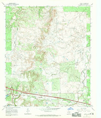
1966 Map of Jayell
USGS Topo · Published 1970About this map
The Texas and Pacific railroad corridor defines the southern landscape of Callahan County, serving as the primary transit artery for the small settlement of Jayell. In the mid-1960s, this region was a hub of industrial extraction, marked by a pervasive network of Oil Fields and a complex system of a Pipeline that crisscrosses the northern drainages. Near the tracks, a Refinery and several Quarries point to a local economy deeply rooted in processing the area's natural resources.
Find a feature on this map
15 named features on this map. Tap any name to fly to it.
Don’t see what you’re looking for? This feature index may not catch every label — zoom into the map to look around manually.
Map Details
Editions of this 1966 Jayell Map
This is the sole edition of this map. No revisions or reprints were ever made.
Other maps of this area

1892 · Albany
USGS Topo · 1:125,000

1893 · Albany
USGS Topo · 1:125,000

1931 · Baird
USGS Topo · 1:125,000

1932 · Baird
USGS Topo · 1:125,000

1954 · Abilene
USGS Topo · 1:250,000

1958 · Abilene
USGS Topo · 1:250,000
1965 · Snyder Lake
USGS Topo · 1:24,000
1965 · Moran
USGS Topo · 1:24,000
1965 · Leeper Creek
USGS Topo · 1:24,000

1966 · Putnam South
USGS Topo · 1:24,000