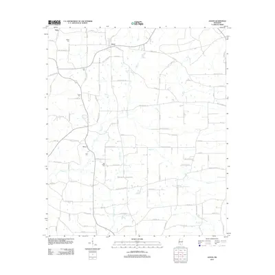
2012 Map of Jayess
USGS Topo · Published 2012About this map
Jayess and Enon anchor this rural Mississippi landscape, where a dense network of local roads follows the subtle drainage patterns of Magees Cr and Carters Cr. The area is defined by its family-named landmarks and local heritage sites, including several significant burial grounds such as Greer Cem, Garner Cem, and the New Bethel Cem located near the center of the survey. The mapping reveals a settlement pattern of dispersed farmsteads and rural residences connected by a web of thoroughfares like Dummy Line Rd and Enon Sartinville Rd. This topography is largely shaped by the winding paths of Leatherwood Cr and Varnell Cr, which cut through the terrain to create the small valleys where communities like Hope Hill and Verna were established. The presence of numerous named roads, such as Jessie Wallace Rd and O'Quinn Rd, reflects the deep-rooted local ownership and genealogical history of Walthall County during this era.
Find a feature on this map
96 named features on this map. Tap any name to fly to it.
Don’t see what you’re looking for? This feature index may not catch every label — zoom into the map to look around manually.
Map Details
Editions of this 2012 Jayess Map
This is the sole edition of this map. No revisions or reprints were ever made.
Other maps of this area

1953 · Natchez
USGS Topo · 1:250,000

1956 · Natchez
USGS Topo · 1:250,000

1959 · Natchez
USGS Topo · 1:250,000

1970 · Kokomo
USGS Topo · 1:24,000

1970 · Mesa
USGS Topo · 1:24,000

1970 · Topeka
USGS Topo · 1:24,000

1970 · Darbun
USGS Topo · 1:24,000

1970 · Jayess
USGS Topo · 1:24,000
1970 · Tilton
USGS Topo · 1:24,000

1972 · Ruth
USGS Topo · 1:24,000