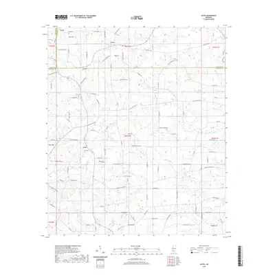
2020 Map of Jayess
USGS Topo · Published 2020About this map
Jayess and Enon anchor this 2020 landscape where the borders of Lincoln, Lawrence, and Walthall counties converge. The terrain is defined by a dense network of local roads named for prominent area families, including Excell Boyd Rd, Jessie Wallace Rd, and Woody Rd. These routes connect dispersed settlements and family sites across the drainage basins of Magees Cr and Leatherwood Cr. Genealogists will find significant value in the documented locations of several rural burial grounds, such as Enon Cem, New Bethel Cem, and Greer Cem, which sit alongside historic church sites. The map also preserves the memory of local commerce and infrastructure through labels like Brister Store Rd and Dummy Line Rd, reflecting the region’s agricultural and timber-hauling history.
Find a feature on this map
94 named features on this map. Tap any name to fly to it.
Don’t see what you’re looking for? This feature index may not catch every label — zoom into the map to look around manually.
Map Details
Editions of this 2020 Jayess Map
This is the sole edition of this map. No revisions or reprints were ever made.
Other maps of this area

1953 · Natchez
USGS Topo · 1:250,000

1956 · Natchez
USGS Topo · 1:250,000

1959 · Natchez
USGS Topo · 1:250,000

1970 · Kokomo
USGS Topo · 1:24,000

1970 · Mesa
USGS Topo · 1:24,000

1970 · Topeka
USGS Topo · 1:24,000

1970 · Darbun
USGS Topo · 1:24,000

1970 · Jayess
USGS Topo · 1:24,000
1970 · Tilton
USGS Topo · 1:24,000

1972 · Ruth
USGS Topo · 1:24,000