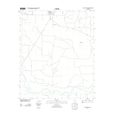
2012 Map of Jayton South
USGS Topo · Published 2012About this map
Jayton serves as the primary settlement on this West Texas landscape, its grid organized around streets like 3rd St and Rose Ave near the northern border. The terrain south of the townsite is defined by the braided channels of the Salt Fork Brazos River, which meanders across the southern portion of the quadrangle. Local aviation is well-represented by two facilities: Kent County Airport situated just south of the main town area and Norris Field Airport further to the east. Water management and drainage are central to the geography here, evidenced by the Jayton City Lake and numerous seasonal tributaries including Little Duck Cr, Salt Cr, and the uniquely named A B C Cr. A network of rural routes, such as Ranch Road 1083 and various county roads, connects the isolated ranchlands to the town center.
Find a feature on this map
28 named features on this map. Tap any name to fly to it.
Don’t see what you’re looking for? This feature index may not catch every label — zoom into the map to look around manually.
Map Details
Editions of this 2012 Jayton South Map
This is the sole edition of this map. No revisions or reprints were ever made.
Other maps of this area

1954 · Lubbock
USGS Topo · 1:250,000

1958 · Seven Diamond L Canyon
USGS Topo · 1:24,000

1958 · Jayton
USGS Topo · 1:24,000

1959 · Girard
USGS Topo · 1:24,000

1968 · Double Mountains
USGS Topo · 1:24,000

1968 · Peacock
USGS Topo · 1:24,000
1969 · A B C Creek
USGS Topo · 1:24,000

1969 · Clairemont East
USGS Topo · 1:24,000

1969 · Jayton South
USGS Topo · 1:24,000
1969 · Gant Hills
USGS Topo · 1:24,000