
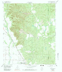
1958 Map of Jayton
USGS Topo · Published 1960About this map
The Fort Worth and Denver (Burlington) railroad cuts a definitive diagonal across this West Texas landscape, anchoring the town of Jayton in the late 1950s. This survey by the Board of Water Engineers reveals a complex drainage system characterized by deeply incised canyons and seasonal watercourses, including Croton Creek and Duck Creek. The proximity of Hot Springs Canyon and Salt Flat indicates the mineral-rich and arid nature of the local geography near the Kent and Stonewall County line.
Find a feature on this map
26 named features on this map. Tap any name to fly to it.
Don’t see what you’re looking for? This feature index may not catch every label — zoom into the map to look around manually.
Map Details
Editions of this 1958 Jayton Map
2 editions found
Other maps of this area

1954 · Lubbock
USGS Topo · 1:250,000

1958 · Pursley House
USGS Topo · 1:24,000

1958 · Southerland Canyon
USGS Topo · 1:24,000

1958 · Seven Diamond L Canyon
USGS Topo · 1:24,000

1959 · Gilpin
USGS Topo · 1:24,000

1959 · Girard
USGS Topo · 1:24,000

1968 · Peacock
USGS Topo · 1:24,000

1969 · Clairemont East
USGS Topo · 1:24,000

1969 · Jayton South
USGS Topo · 1:24,000
1985 · Aspermont
USGS Topo · 1:100,000