
1958 Map of Pursley House
USGS Topo · Published 1959About this map
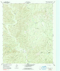
Pursley House serves as a central landmark in this 1958 survey of the West Texas breaks, where the corner of Dickens, King, Kent, and Stonewall counties meets. The landscape is defined by an intricate network of drainages and named canyons, including the curiously named North Pole Canyon and South Pole Canyon. Ranching infrastructure is the primary evidence of human activity, represented by operations like Beggs Ranch and various water sources such as White Face Windmill, Sullivan Windmill, and Galloway Tank.
Find a feature on this map
34 named features on this map. Tap any name to fly to it.
Don’t see what you’re looking for? This feature index may not catch every label — zoom into the map to look around manually.
Map Details
Editions of this 1958 Pursley House Map
2 editions found
Other maps of this area

1954 · Lubbock
USGS Topo · 1:250,000

1958 · Southerland Canyon
USGS Topo · 1:24,000

1958 · Seven Diamond L Canyon
USGS Topo · 1:24,000

1958 · Jayton
USGS Topo · 1:24,000

1959 · Gilpin
USGS Topo · 1:24,000

1959 · Girard
USGS Topo · 1:24,000

1968 · Pitchfork Ranch
USGS Topo · 1:24,000

1968 · Croton Camp
USGS Topo · 1:24,000

1968 · Pitchfork Flats
USGS Topo · 1:24,000

1985 · Dickens
USGS Topo · 1:100,000